WPC Home
About the WPC
WPC Product Information
Current Products
Experimental Products
Satellite Imagery
Latest Radar Imagery
Current Watches/Warnings
Storm Summaries
WPC Verification
Model Diagnostics/Verif.
Daily Weather Map
Development and Training
International Desks
Tropical Products
What's New
FAQs
Other Sites
Meteorological Calculators
|
|
Weather Prediction Center
College Park, MD
Current Products
Text Products
Graphical Products
- Surface Analysis -
- The Surface Analysis images have been moved to our new
Surface Analysis page. Please
update your bookmarks accordingly.
- Short Range Forecasts (Fronts and Precipitation) -
[about these products]
[Surface Front Symbols/Codes]
[Precipitation Areas/Symbols]
[top of page]
- 6 Hour Forecast (Valid 06 or 18 UTC) :
- 12 Hour Forecast (Valid 00 or 12 UTC) :
- 18 Hour Forecast (Valid 06 or 18 UTC) :
- 24 Hour Forecast (Valid 00 or 12 UTC) :
- 30 Hour Forecast (Valid 06 or 18 UTC) :
- 36 Hour Forecast (Valid 00 or 12 UTC) :
- 48 Hour Forecast (Valid 00 or 12 UTC) :
- 60 Hour Forecast (Valid 00 or 12 UTC) :
- Quantitative Precipitation Forecasts (QPF)
- *PLEASE NOTE* The QPF graphical products have moved to
our new QPF page. Please update
your links accordingly.
- Medium Range Forecasts -
[about these products]
[top of page]
- Heat Index Forecasts -
[about these products]
[top of page]
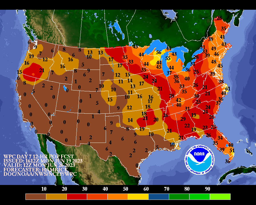
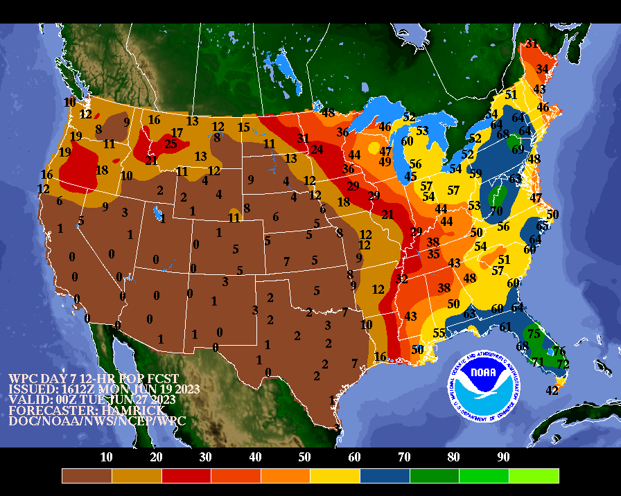
- Depicted below are probability forecasts of the daily maximum, daily minimum, and daily mean
heat index reaching or exceeding a given threshold during the medium-range period (Days 3-7).
The three thresholds for the maximum are 95, 100, and 105 degrees F; for the minimum, they are
75, 80, and 85 degrees F; and for the mean, they are 85, 90, and 95 degrees F.
- Maximum Heat Index Forecasts
- Minimum Heat Index Forecasts
- Mean Heat Index Forecasts
- Day 4-8 Alaskan Forecasts -
[about these products]
[top of page]
- Significant River Flood Outlook
- National Weather Service Day 3-10 U.S. Threats page
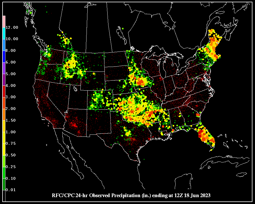
- 24-hour precipitation totals (valid 12Z - 12Z)
[printable version] *NOTE* new location of these files
For a text file containing precipitation values for each station,
click here, and look for the
files named usa-dlyprcp-yyyymmdd. (You may need to shift-leftclick to download these files)
- NWS FAX Products - (in TIFF format)
- Long Range Products (From the Climate Prediction Center)
Questions? Comments? Click here to send mail to the WPC.
Last Modified June 22, 2023
|
![[Terrain/Satellite Gif]](../basicwx/91f.gif)
![[Color Gif]](../basicwx/91fwbgus.gif)
![[B/W Gif]](../basicwx/91fbwus.gif)
![[Terrain/Satellite JPG]](../basicwx/91f.jpg)
![[Color JPG]](../basicwx/91fwbgus.jpg)
![[B/W JPG]](../basicwx/91fbwus.jpg)
![[Terrain/Satellite Gif]](../basicwx/91f00.gif)
![[Color Gif]](../basicwx/91f00wbg.gif)
![[B/W Gif]](../basicwx/91f00bw.gif)
![[Terrain/Satellite Gif]](../basicwx/91f12.gif)
![[Color Gif]](../basicwx/91f12wbg.gif)
![[B/W Gif]](../basicwx/91f12bw.gif)
![[Terrain/Satellite Gif]](../basicwx/92f.gif)
![[Color Gif]](../basicwx/92fwbgus.gif)
![[B/W Gif]](../basicwx/92fbwus.gif)
![[Terrain/Satellite JPG]](../basicwx/92f.jpg)
![[Color JPG]](../basicwx/92fwbgus.jpg)
![[B/W JPG]](../basicwx/92fbwus.jpg)
![[Terrain/Satellite Gif]](../basicwx/92f00.gif)
![[Color Gif]](../basicwx/92f00wbg.gif)
![[B/W Gif]](../basicwx/92f00bw.gif)
![[Terrain/Satellite Gif]](../basicwx/92f12.gif)
![[Color Gif]](../basicwx/92f12wbg.gif)
![[B/W Gif]](../basicwx/92f12bw.gif)
![[Terrain/Satellite Gif]](../basicwx/93f.gif)
![[Color Gif]](../basicwx/93fwbgus.gif)
![[B/W Gif]](../basicwx/93fbwus.gif)
![[Terrain/Satellite JPG]](../basicwx/93f.jpg)
![[Color JPG]](../basicwx/93fwbgus.jpg)
![[B/W JPG]](../basicwx/93fbwus.jpg)
![[Terrain/Satellite Gif]](../basicwx/93f00.gif)
![[Color Gif]](../basicwx/93f00wbg.gif)
![[B/W Gif]](../basicwx/93f06bw.gif)
![[Terrain/Satellite Gif]](../basicwx/93f12.gif)
![[Color Gif]](../basicwx/93f12wbg.gif)
![[B/W Gif]](../basicwx/93f12bw.gif)
![[Terrain/Satellite Gif]](../basicwx/94f.gif)
![[Color Gif]](../basicwx/94fwbgus.gif)
![[B/W Gif]](../basicwx/94fbwus.gif)
![[Terrain/Satellite JPG]](../basicwx/94f.jpg)
![[Color JPG]](../basicwx/94fwbgus.jpg)
![[B/W JPG]](../basicwx/94fbwus.jpg)
![[Terrain/Satellite Gif]](../basicwx/94f00.gif)
![[Color Gif]](../basicwx/94f00wbg.gif)
![[B/W Gif]](../basicwx/94f00bw.gif)
![[Terrain/Satellite Gif]](../basicwx/94f12.gif)
![[Color Gif]](../basicwx/94f12wbg.gif)
![[B/W Gif]](../basicwx/94f12bw.gif)
![[Terrain/Satellite Gif]](../basicwx/95f.gif)
![[Color Gif]](../basicwx/95fwbgus.gif)
![[B/W Gif]](../basicwx/95fbwus.gif)
![[Terrain/Satellite JPG]](../basicwx/95f.jpg)
![[Color JPG]](../basicwx/95fwbgus.jpg)
![[B/W JPG]](../basicwx/95fbwus.jpg)
![[Terrain/Satellite Gif]](../basicwx/95f00.gif)
![[Color Gif]](../basicwx/95f00wbg.gif)
![[B/W Gif]](../basicwx/95f00bw.gif)
![[Terrain/Satellite Gif]](../basicwx/95f12.gif)
![[Color Gif]](../basicwx/95f12wbg.gif)
![[B/W Gif]](../basicwx/95f12bw.gif)
![[Terrain/Satellite Gif]](../basicwx/96f.gif)
![[Color Gif]](../basicwx/96fwbgus.gif)
![[B/W Gif]](../basicwx/96fbwus.gif)
![[Terrain/Satellite JPG]](../basicwx/96f.jpg)
![[Color JPG]](../basicwx/96fwbgus.jpg)
![[B/W JPG]](../basicwx/96fbwus.jpg)
![[Terrain/Satellite Gif]](../basicwx/96f00.gif)
![[Color Gif]](../basicwx/96f00wbg.gif)
![[B/W Gif]](../basicwx/96f00bw.gif)
![[Terrain/Satellite Gif]](../basicwx/96f12.gif)
![[Color Gif]](../basicwx/96f12wbg.gif)
![[B/W Gif]](../basicwx/96f12bw.gif)
![[Terrain/Satellite Gif]](../basicwx/98f.gif)
![[Color Gif]](../basicwx/98fwbgus.gif)
![[B/W Gif]](../basicwx/98fbwus.gif)
![[Terrain/Satellite JPG]](../basicwx/98f.jpg)
![[Color JPG]](../basicwx/98fwbgus.jpg)
![[B/W JPG]](../basicwx/98fbwus.jpg)
![[Terrain/Satellite Gif]](../basicwx/98f00.gif)
![[Color Gif]](../basicwx/98f00wbg.gif)
![[B/W Gif]](../basicwx/98f00bw.gif)
![[Terrain/Satellite Gif]](../basicwx/98f12.gif)
![[Color Gif]](../basicwx/98f12wbg.gif)
![[B/W Gif]](../basicwx/98f12bw.gif)
![[Terrain/Satellite Gif]](../basicwx/99f.gif)
![[Color Gif]](../basicwx/99fwbgus.gif)
![[B/W Gif]](../basicwx/99fbwus.gif)
![[Terrain/Satellite JPG]](../basicwx/99f.jpg)
![[Color JPG]](../basicwx/99fwbgus.jpg)
![[B/W JPG]](../basicwx/99fbwus.jpg)
![[Terrain/Satellite Gif]](../basicwx/99f00.gif)
![[Color Gif]](../basicwx/99f00wbg.gif)
![[B/W Gif]](../basicwx/99f00bw.gif)
![[Terrain/Satellite Gif]](../basicwx/99f12.gif)
![[Color Gif]](../basicwx/99f12wbg.gif)
![[B/W Gif]](../basicwx/99f12bw.gif)
![[Full Color Gif]](../medr/9jh_conus.gif)
![[Color/White Gif]](../medr/9jhwbg_conus.gif)
![[B/W Gif]](../medr/9jhbw_conus.gif)
![[Full Color Gif]](../medr/9kh_conus.gif)
![[Color/White Gif]](../medr/9khwbg_conus.gif)
![[B/W Gif]](../medr/9khbw_conus.gif)
![[Full Color Gif]](../medr/9lh_conus.gif)
![[Color/White Gif]](../medr/9lhwbg_conus.gif)
![[B/W Gif]](../medr/9lhbw_conus.gif)
![[Full Color Gif]](../medr/9mh_conus.gif)
![[Color/White Gif]](../medr/9mhwbg_conus.gif)
![[B/W Gif]](../medr/9mhbw_conus.gif)
![[Full Color Gif]](../medr/9nh_conus.gif)
![[Color/White Gif]](../medr/9nhwbg_conus.gif)
![[B/W Gif]](../medr/9nhbw_conus.gif)
![[Color/White Gif]](../medr/5dayfcst_wbg_conus.gif)
![[B/W Gif]](../medr/5dayfcst_bw_conus.gif)
![[Full Color Gif]](../medr/9jh.gif)
![[Color/White Gif]](../medr/9jhwbg.gif)
![[B/W Gif]](../medr/9jhbw.gif)
![[Full Color Gif]](../medr/9kh.gif)
![[Color/White Gif]](../medr/9khwbg.gif)
![[B/W Gif]](../medr/9khbw.gif)
![[Full Color Gif]](../medr/9lh.gif)
![[Color/White Gif]](../medr/9lhwbg.gif)
![[B/W Gif]](../medr/9lhbw.gif)
![[Full Color Gif]](../medr/9mh.gif)
![[Color/White Gif]](../medr/9mhwbg.gif)
![[B/W Gif]](../medr/9mhbw.gif)
![[Full Color Gif]](../medr/9nh.gif)
![[Color/White Gif]](../medr/9nhwbg.gif)
![[B/W Gif]](../medr/9nhbw.gif)
![[Forecast]](../medr/DAY3_MIN_wbg.gif)
![[Color-filled Forecast]](../medr/DAY3_MIN_filled.gif)
![[Departures from Normal/Climo]](../medr/DAY3_MIN_ANOM_wbg.gif)
![[Forecast]](../medr/DAY4_MIN_wbg.gif)
![[Color-filled Forecast]](../medr/DAY4_MIN_filled.gif)
![[Departures from Normal/Climo]](../medr/DAY4_MIN_ANOM_wbg.gif)
![[Forecast]](../medr/DAY5_MIN_wbg.gif)
![[Color-filled Forecast]](../medr/DAY5_MIN_filled.gif)
![[Departures from Normal/Climo]](../medr/DAY5_MIN_ANOM_wbg.gif)
![[Forecast]](../medr/DAY6_MIN_wbg.gif)
![[Color-filled Forecast]](../medr/DAY6_MIN_filled.gif)
![[Departures from Normal/Climo]](../medr/DAY6_MIN_ANOM_wbg.gif)
![[Forecast]](../medr/DAY7_MIN_wbg.gif)
![[Color-filled Forecast]](../medr/DAY7_MIN_filled.gif)
![[Departures from Normal/Climo]](../medr/DAY7_MIN_ANOM_wbg.gif)
![[Forecast]](../medr/DAY3_MAX_wbg.gif)
![[Color-filled Forecast]](../medr/DAY3_MAX_filled.gif)
![[Departures from Normal/Climo]](../medr/DAY3_MAX_ANOM_wbg.gif)
![[Forecast]](../medr/DAY4_MAX_wbg.gif)
![[Color-filled Forecast]](../medr/DAY4_MAX_filled.gif)
![[Departures from Normal/Climo]](../medr/DAY4_MAX_ANOM_wbg.gif)
![[Forecast]](../medr/DAY5_MAX_wbg.gif)
![[Color-filled Forecast]](../medr/DAY5_MAX_filled.gif)
![[Departures from Normal/Climo]](../medr/DAY5_MAX_ANOM_wbg.gif)
![[Forecast]](../medr/DAY6_MAX_wbg.gif)
![[Color-filled Forecast]](../medr/DAY6_MAX_filled.gif)
![[Departures from Normal/Climo]](../medr/DAY6_MAX_ANOM_wbg.gif)
![[Forecast]](../medr/DAY7_MAX_wbg.gif)
![[Color-filled Forecast]](../medr/DAY7_MAX_filled.gif)
![[Departures from Normal/Climo]](../medr/DAY7_MAX_ANOM_wbg.gif)
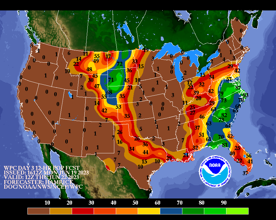
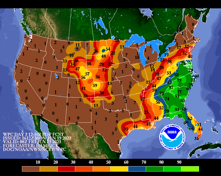
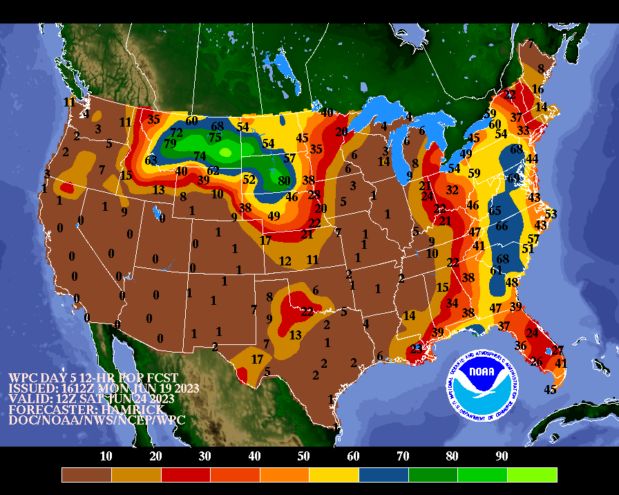
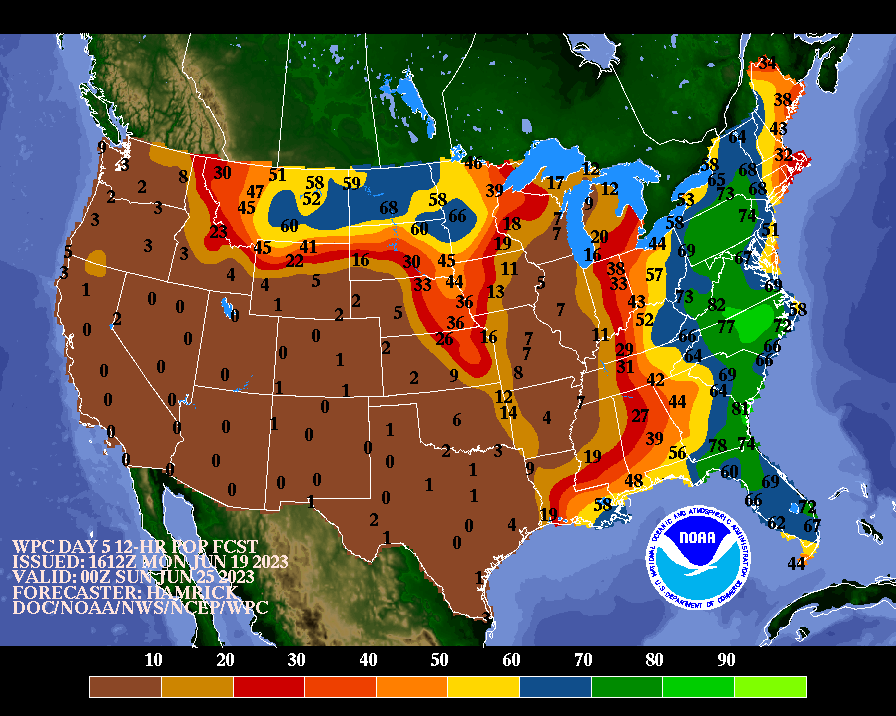
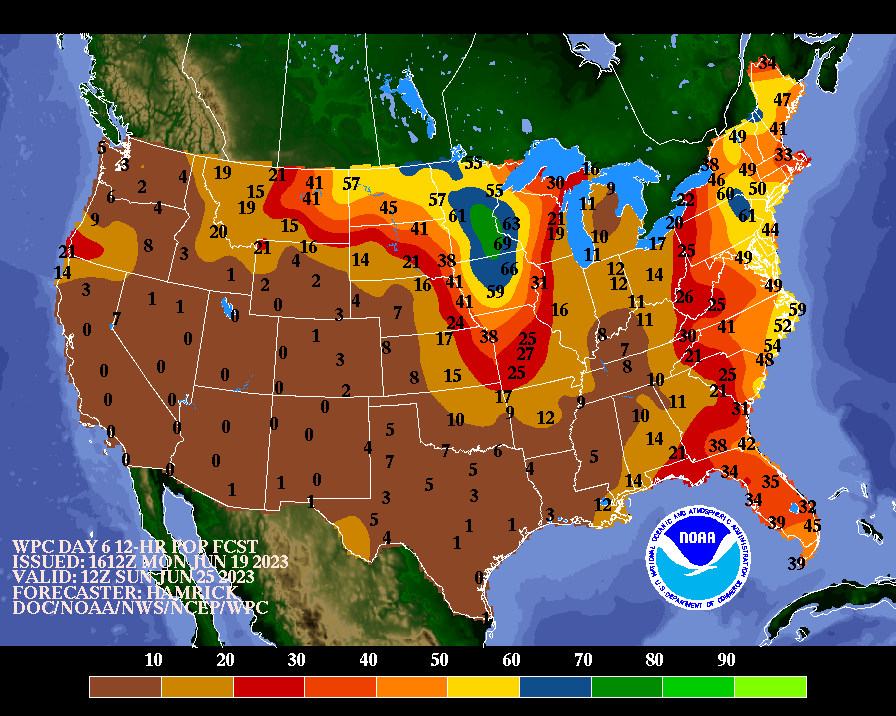
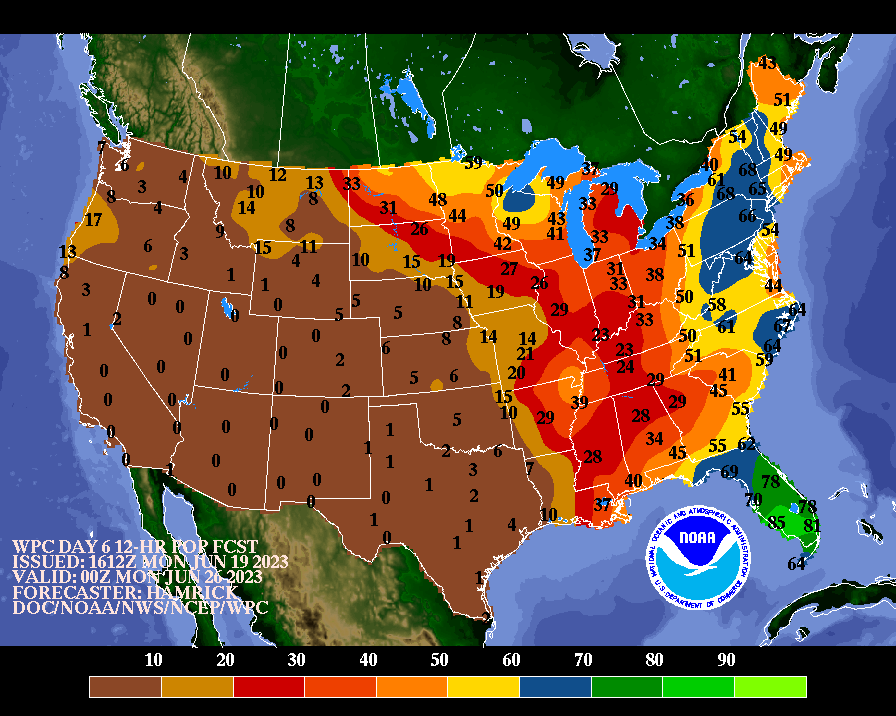
![[Forecast]](../medr/DAY3_POP_wbg.gif)
![[Color-filled Forecast]](../medr/DAY3_POP_filled.gif)
![[Departures from Normal/Climo]](../medr/DAY3_POP_ANOM_wbg.gif)
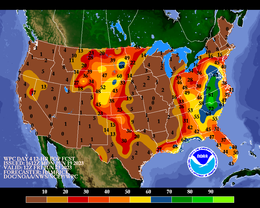
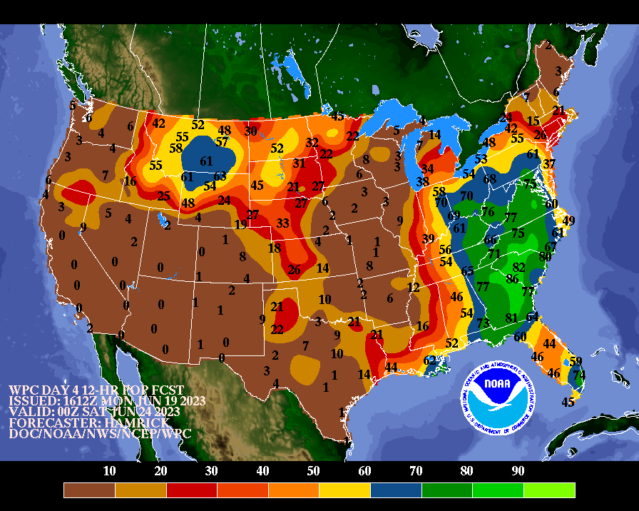
![[Forecast]](../medr/DAY4_POP_wbg.gif)
![[Color-filled Forecast]](../medr/DAY4_POP_filled.gif)
![[Departures from Normal/Climo]](../medr/DAY4_POP_ANOM_wbg.gif)
![[Forecast]](../medr/DAY5_POP_wbg.gif)
![[Color-filled Forecast]](../medr/DAY5_POP_filled.gif)
![[Departures from Normal/Climo]](../medr/DAY5_POP_ANOM_wbg.gif)
![[Forecast]](../medr/DAY6_POP_wbg.gif)
![[Color-filled Forecast]](../medr/DAY6_POP_filled.gif)
![[Departures from Normal/Climo]](../medr/DAY6_POP_ANOM_wbg.gif)
![[Forecast]](../medr/DAY7_POP_wbg.gif)
![[Color-filled Forecast]](../medr/DAY7_POP_filled.gif)
![[Departures from Normal/Climo]](../medr/DAY7_POP_ANOM_wbg.gif)
![[Day 3]](../medr/DAY3_MX_MN_POP_wbg.gif)
![[Day 4]](../medr/DAY4_MX_MN_POP_wbg.gif)
![[Day 5]](../medr/DAY5_MX_MN_POP_wbg.gif)
![[Day 6]](../medr/DAY6_MX_MN_POP_wbg.gif)
![[Day 7]](../medr/DAY7_MX_MN_POP_wbg.gif)
![[Color on White]](/medr/95e12wbg.gif)
![[Color Fill]](/qpf/p120i12.gif)
![[Color on White]](../medr/95Awbg.gif)
![[Color on White]](../medr/95Bwbg.gif)
![[Color/White Gif]](/alaska/ak_d4wbg.gif)
![[B/W Gif]](/alaska/ak_d4bw.gif)
![[Color/White Gif]](/alaska/ak_d5wbg.gif)
![[B/W Gif]](/alaska/ak_d5bw.gif)
![[Color/White Gif]](/alaska/ak_d6wbg.gif)
![[B/W Gif]](/alaska/ak_d6bw.gif)
![[Color/White Gif]](/alaska/ak_d7wbg.gif)
![[B/W Gif]](/alaska/ak_d7bw.gif)
![[Color/White Gif]](/alaska/ak_d8wbg.gif)
![[B/W Gif]](/alaska/ak_d8bw.gif)
![[printable version]](../mklein/pptgif/cpc/cpc12_p24i_prnt.gif)